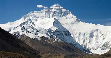


Earth
Most Awesome Places In Norway - Top 7
Updated Feb 13, 2020
Norway is home to some of the most spectacular places on Earth. We have picked our favorites.
Norway has a unique landscape that offers stunning views many of us can only dream about seeing in real life. We have had the fortune to travel in Norway many times, and we want to share our experiences with you. Without further introduction – here is our list of the most awesome places in Norway. Also, do not miss our guide to The Most Scenic Road In Norway or our list of the Most Beautiful Cities, Towns And Villages In Norway.
Norway has a unique landscape that offers stunning views many of us can only dream about seeing in real life. We have had the fortune to travel in Norway many times, and we want to share our experiences with you. Without further introduction – here is our list of the most awesome places in Norway. Also, do not miss our guide to The Most Scenic Road In Norway or our list of the Most Beautiful Cities, Towns And Villages In Norway.
Advertisement:
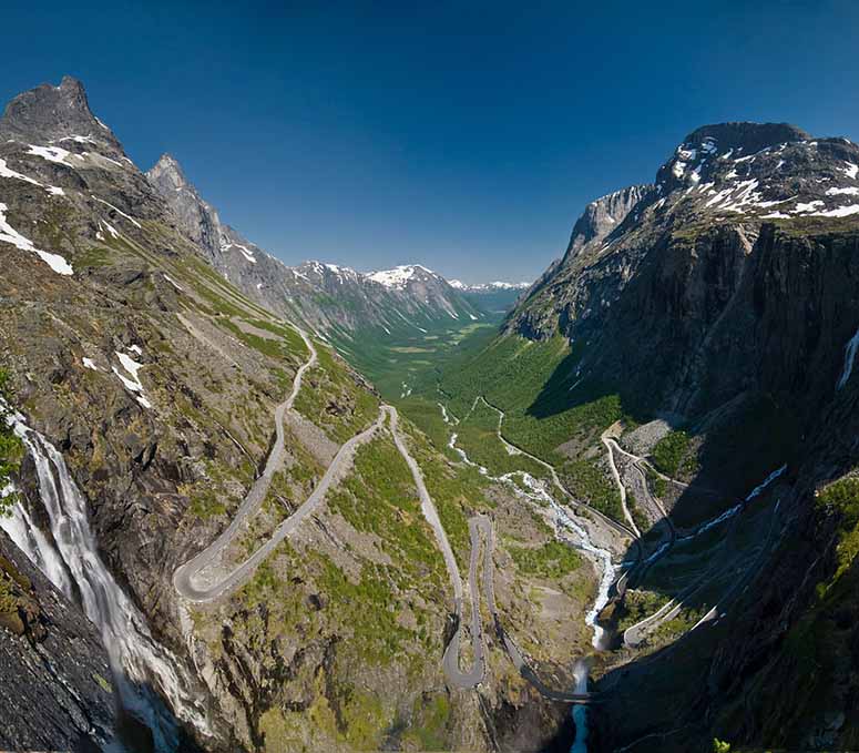
7. Trollstigen
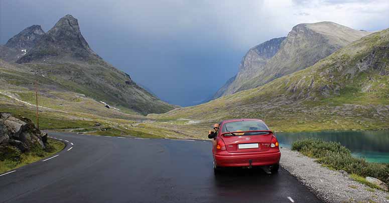
Norway is a country where the infrastructure is adapted to the mountainous landscape. Winding highways squeeze through valleys and hairpinned county roads climb up and down steep mountain sides.
The most spectacular road is probably Trollstigen (the Troll's Ladder in English), near the town of Åndalsnes. The road twists up three mountainsides to Stigrøra, 858 m (2,815 ft) above sea level.[1]
On the summit of Trollstigen is a big parking lot and a tourist centre, from which you can walk 5 minutes on a cemented walkway to a lookout platform, from where the photo was taken. You also have a good view of the Stigfossen waterfall from here.
For those wanting the hardcore experience, there is a hiking trail that more or less goes straight up the mountain pass.
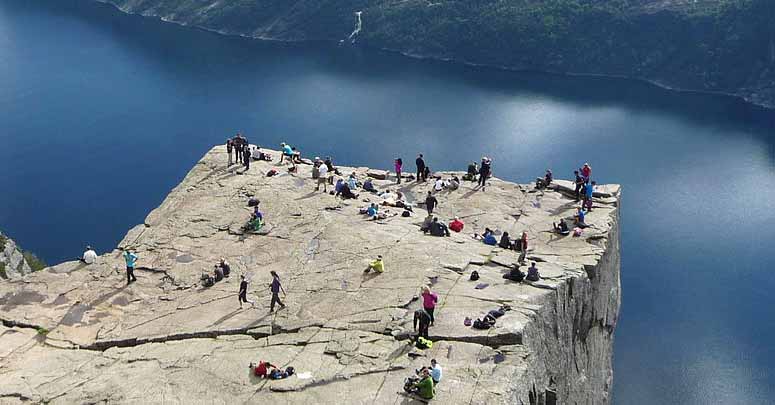
6. Preikestolen
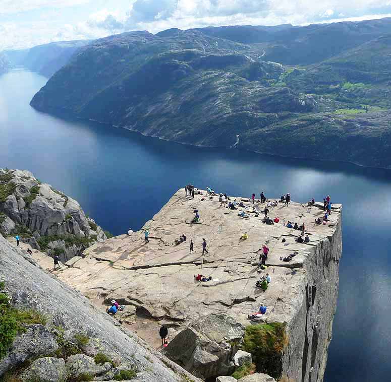
Preikestolen (the Pulpit Rock) is a spectacular mountain plateau 604 m (1,982 ft) above the Lysefjord.[2] The plateau measures about 25x25 m (82x82 ft),[2] and three of its sides fall almost vertically into the fjord below.
Despite its towering appearance, Preikestolen is quite easy to reach. First, you drive to the mountain cabin Preikestolshytta, and then hike about 3 km (2 mi).
The Pulpit Rock was probably formed during the most recent Ice Age, when a glacier covered the Lysefjord. Water that had entered cracks in the mountainsides froze, prying loose large chunks of stones, which were then carried away by the moving glacier.[2] Still standing was this angular creation.
A huge crack traverses Preikestolen today, one that has even expanded in recent years, but geologists are pretty sure the Pulpit Rock will not collapse in the near future.[3]
Advertisement:
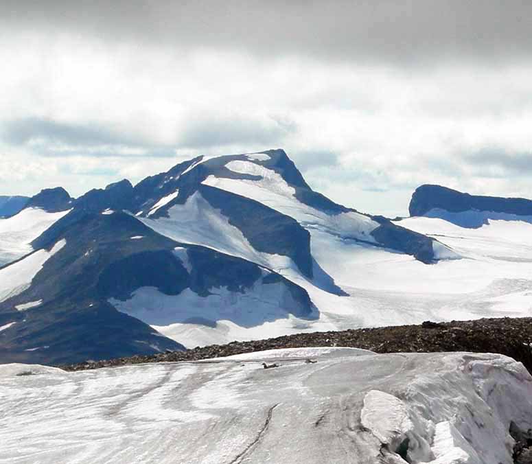
5. Galdhøpiggen
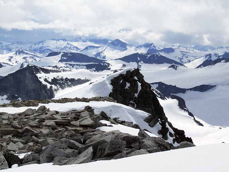
Galdhøpiggen is the highest mountain in Norway, as well as in all the Nordic countries. The peak measures 2,468.9 m (8.100 ft)[5] and has a wonderful view of the surrounding mountains in the Jotunheimen area.
The mountain is relatively easily climbed from the north, starting from the mountain lodge Juvasshytta at 1,841 m (6,040 ft)[4]. It is recommended to join a guided group, since you have to cross a glacier. The summit and the top cabin can be crowded with tourists.
One can also ignore the summit hike and just enjoy the spectacular car ride up to Juvasshytta. The drive down again can be even more thrilling – when the brakes start to smoke, stop the car and let the discs cool.
The upper photo shows the view from the summit of Galdhøpiggen toward the west. The bottom photo of Galdhøpiggen is taken from the nearby mountain Glittertind, the second highest mountain in Norway at 2,456.8 m (8,060 ft) – or 2,452 m (8,045 ft) excluding the glacier on the top.[9]
4. Besseggen
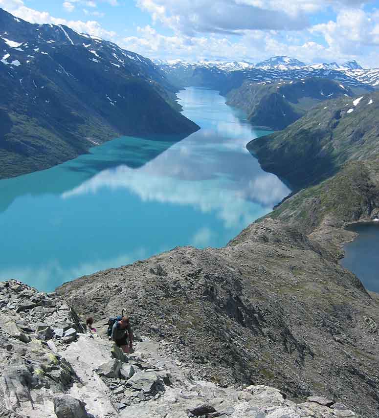
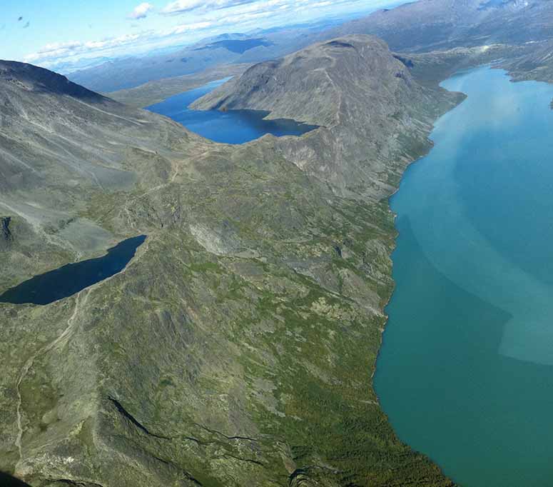
Besseggen is a mountain ridge in Jotunheimen that runs between the two mountain lodges Gjendesheim and Memurubu. The hike on Besseggen is known for its amazing views, especially that over the light blue lake Gjende and the dark blue lake Bessvatnet. The light blue color of Gjende is a result of glacial melt water filled with small rock particles that reflect the sunlight.
Most people who hike the Besseggen ridge start by taking a boat ride on Gjende to Memurubu, from where they hike the ridge back toward Gjendesheim. You then hike "inward" in the bottom photo, on the trampled path that is visible. After a while, you reach the narrow passage between the lakes, which marks the start of the actual Besseggen ridge. The slope starts to steepen, and on your right is pretty much a vertical drop. After a while of scrambling ("monkey-climbing"), you reach the top of Veslfjellet, 1,743 m (5,719 ft) above sea level,[6] before beginning the descent to Gjendesheim.
Besseggen is one of Norway's most popular mountain hikes, and some say that it is a must-do hike for all Norwegians.[10] The hike is rather demanding, and if you are prone to vertigo, you should consider starting at Gjendesheim. You can then turn back whenever, and reach the top without having to accomplish the ridge.
3. Romsdalseggen
Romsdalseggen is another ridge that offers an awesome scenery. It is situated right next to the port town of Åndalsnes, and runs between the two mountain peaks Blånebba and Mjølvafjellet.
The starting point for the hike is most commonly reached by bus from Åndalsnes. A trail leads upward from the bus stop, and reaches the Romsdalseggen ridge midway between Blånebba and Mjølvafjellet. The trail continues over Mjølvafjellet and then steeply downhill to Åndalsnes.
The hike is demanding, and the narrowest part of the ridge is pretty hair-raising. Luckily, it can be bypassed by choosing a different trail halfway up the mountain.
From the top of the Romsdalseggen ridge are spectacular views in all directions. The ridge drops almost straight down into the Romsdalen valley, where Trollveggen (the Troll Wall), Europe's tallest vertical, overhanging rock face with 1,000 vertical meters (3,300 ft),[7] towers on the opposite side. To the south are some of Norway's most pointy peaks, and to the north lies the Isfjord.
If you want to travel to Åndalsnes and Romsdalseggen, you can take the Rauma Railway (seen in the commercial) – a beautiful railway that goes through the Romsdalen valley.
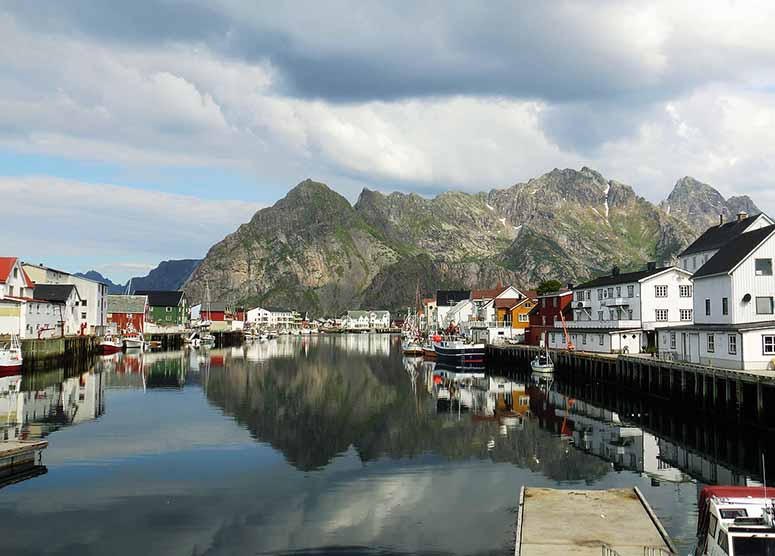
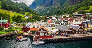
2. Lofoten
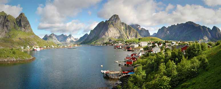
Lofoten is that archipelago in northern Norway that, on a map, stands out as a downwardly bent tongue in the Atlantic Ocean. Lofoten consists, from east to west, of the islands Austvågøya, Gimsøya, Vestvågøya, Flakstadøya and Moskenesøya, as well as the more isolated islands Værøy and Røst further out, plus lots of smaller islands.
Almost every island of Lofoten rises like a mountain directly out of the sea, a feature that becomes more pronounced the further out into the archipelago you get.
Lofoten is quite large, but is usually visited by making a tour through most of the islands. There is, after all, only a couple of major roads here. If we would have to recommend one single place on Lofoten, it would probably be Reine (upper photo), a beautiful fishing village in outer Lofoten overlooking the mountainous coastline. Another candidate is Henningsvær (bottom photo), a fishing village in inner Lofoten, also with a beatiful view.
Besides its stunning scenery, Lofoten is known for its rather unique animal life, which includes puffins, seals, sperm whales and even killer whales – all of which can be seen on guided tours.
1. Geirangerfjord
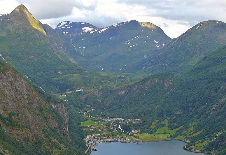
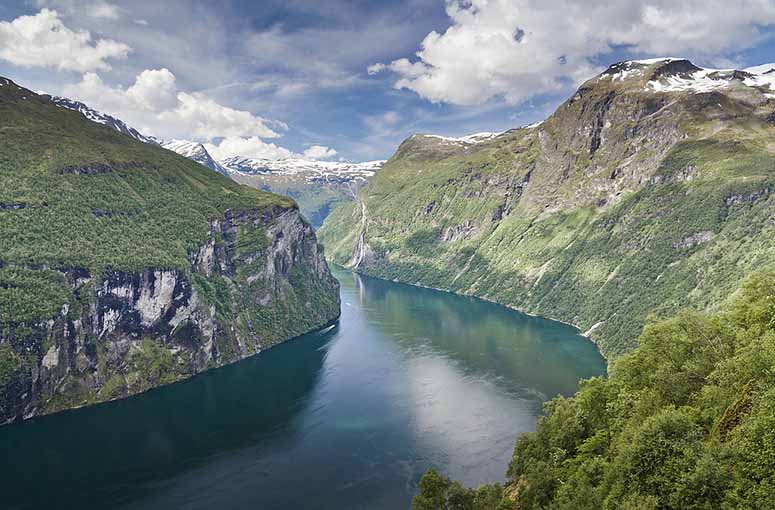
Norway is known for its fjords, and the most awesome and beautiful, in our opinion, is the Geirangerfjord. The fjord is surrounded by several mountain peaks higher than 1,600 m (5,200 ft), that drop steeply into the water. Entire mountainsides can be seen from top to bottom, which is an impressive sight.
The two photos are taken from Ørnesvingen (the Eagle Road) – one of the two roads that wind down to the fjord. The top photo shows the end of the fjord, where the small village of Geiranger is located. Behind Geiranger is the mountain Dalsnibba, which can be summited by car via a spectacular hairpinned road. The bottom photo shows the view in the other direction, where you almost can see the beginning of the fjord (the Geingerfjord is a branch off another fjord).
The waterfall on the bottom photo is called De Syv Søstrene (The Seven Sisters) and is 250 m (820 ft) high[8]. Perched on the mountainsides framing the fjord are four old farmhouses, of which the popular Skageflå, opposite the Seven Sisters, can be reached by an airy hike above the cliffs in the bottom photo, or by a dizzying trail leading almost straight up from the fjord.
A common sight in the fjord is two or three large cruise ships anchored outside Geiranger, packed with tourists eager for sightseeing. If you are seeking some alone-time, an excursion by the fjord will probably give you that, since most tourists only visit the village of Geiranger and the viewpoints along the roads.
References
[1]
"National Tourist Route Trollstigen". Visit Norway. Updated Feb 11, 2020. Retrieved Feb 13, 2020.
[2]
"Preikestolen". Visit Norway. Updated Feb 11, 2020. Retrieved Feb 13, 2020.
[3]
"Preikestolen slår sprekker" (in Norwegian). Aftenposten. Updated May 15, 2013. Retrieved Feb 13, 2020.
[4]
"Juvasshytta" (in Norwegian). Norgeskart.no. Retrieved Feb 13, 2020.
[5]
"Høyeste fjelltopp i hver kommune" (in Norwegian). Kartverket.no. Updated Sep 18, 2018. Retrieved Feb 13, 2020.
[6]
"The Besseggen Ridge In Jotunheimen". Visit Norway. Updated Feb 11, 2020. Retrieved Feb 13, 2020.
[7]
"Trollveggen And Romsdalen Valley". Visit Norway. Updated Feb 11, 2020. Retrieved Feb 13, 2020.
[8]
"The Seven Sisters". Fjord Norway. Retrieved Feb 13, 2020.
[9]
"Ingen vet helt sikkert hvor høyt dette fjellet er" (in Norwegian). NRK.no. Updated Aug 17, 2018. Retrieved Feb 13, 2020.
[10]
"Besseggen Ridge In Jotunheimen". Visit Norway. Updated Jan 29, 2018. Retrieved Feb 13, 2020.


Related

Latest

Architecture
Earth
Earth
Sports
Technology
People

Technology
Technology
Sports